

Tanzania Travelers
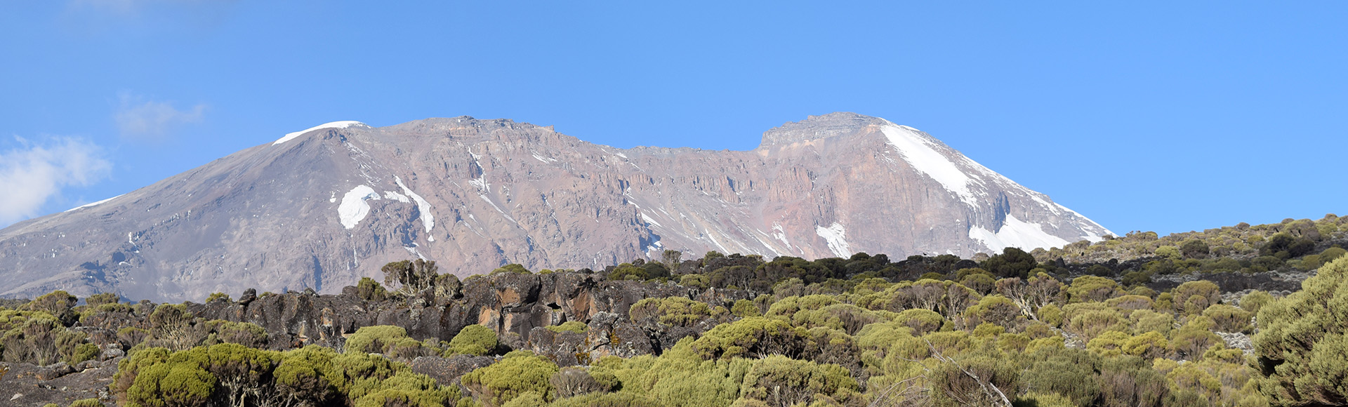
Mount Kilimanjaro at sunrise
5,895 m · The Roof of Africa

Climbing Mount Kilimanjaro The right route for you.

At 5,895 metres, Kilimanjaro is the highest mountain in Africa and the tallest free-standing mountain on Earth. Its snow-capped summit is one of the world's great trekking prizes — and it's within reach of any determined, reasonably fit adventurer.

Compare Routes
97% summit success
One of the highest in Tanzania
Full acclimatisation
Climb high, sleep low
First summit 1889
Hans Meyer's historic ascent
Stratovolcano
Dormant volcanic giant
4,900 m above base
Tallest free-standing mountain
Ecological zones

Five climate zones in one climb

  • Arctic Summit Zone5,000 – 5,895 m
  • Alpine Desert Zone4,000 – 5,000 m
  • Heath and Moorland Zone2,800 – 4,000 m
  • Rainforest Zone1,800 – 2,800 m
  • Cultivation Zone800 – 1,800 m
When to climb

Best time to climb

Year at a glance
Best Shoulder Avoid
JanFebMarAprMayJunJulAugSepOctNovDec
Jan – Feb
Best
Warm, quiet, clear skies.
March
Shoulder
Drier early, wetter late.
Apr – May
Avoid
Long rains — wet trails.
Jun – Oct
Best
Main dry season — most reliable.
November
Shoulder
Short rains, fewer climbers.
Dec
Best
Short dry window, warm and clear.
Choose your route

Four routes to the summit.

The route shapes the climb. We'll help you choose based on your fitness, schedule and the kind of summit day you want.

The Scenic Route

Lemosho Route

The most beautiful — and most successful — way up Kilimanjaro.

Approaches Kilimanjaro from the quiet west, crossing the Shira Plateau and joining the Southern Circuit for the summit push. Long, gradual acclimatisation and huge summit-day success rates.

Idéal pour
First-time high-altitude climbers who want the best chance of success.
Difficulté
Modéré
Paysages
Exceptional — rainforest, plateau, alpine desert, glaciers
Affluence
Quiet on days 1–3, busier from Barranco onward
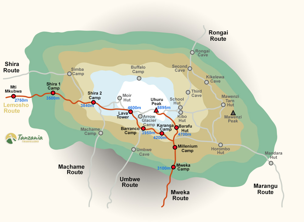
Lemosho Route trail map
Duréefrom $1,800

Voie Lemosho — 8 jours

Notre itinéraire sur le Kilimanjaro qui affiche le meilleur taux de réussite. La nuit supplémentaire au camp de Karanga offre à votre corps une journée de plus au-dessus de 4,000 m avant l'assaut final du sommet — le facteur déterminant pour atteindre Uhuru Peak en pleine forme. Recommandé pour les novices en haute altitude et pour tous ceux qui souhaitent réellement profiter de l'ascension plutôt que de la subir.

Informations clés

Point de départ
Londorossi Gate (2,250 m)
Point d'arrivée
Mweka Gate (1,640 m)
Distance
≈ 70 km / 42 mi round trip
Point culminant
Uhuru Peak · 5,895 m
Taille du groupe
Privé, 1–12 climbers
Meilleure saison
Jan–Mar, Jun–Oct
Difficulté
Modéré
Fréquentation
Faible à modérée
Paysages
Exceptionnel
Hébergement
Tentes de montagne

Itinerary at a glance

  1. 1
    Moshi → Londorossi Gate → Mti Mkubwa

    Morning briefing and gear check in Moshi. Drive 4 hours via Boma Ng'ombe to the Londorossi Gate (2,250 m) for park registration.

    Repas : L, D· Camp Mti Mkubwa · 2,820 m
  2. 2
    Mti Mkubwa → Camp Shira 1

    Climb out of the rainforest into the heather and moorland zone. 5–6 hours.

    Repas : B, L, D· Camp Shira 1 · 3,505 m
  3. 3
    Shira 1 → Camp Shira 2

    An easier acclimatisation day traversing the Shira Plateau with Kibo's glaciers ahead and Mt. Meru behind. 4–5 hours.

    Repas : B, L, D· Camp Shira 2 · 3,810 m
  4. 4
    Shira 2 → Lava Tower → Barranco Camp

    Ascend the Southern Circuit to Lava Tower (4,630 m) for lunch — the classic 'climb high, sleep low' day. 6–7 hours.

    Repas : B, L, D· Barranco Camp · 3,960 m
  5. 5
    Barranco → Karanga Camp

    A short but spectacular day. 4–5 hours.

    Repas : B, L, D· Karanga Camp · 3,995 m
  6. 6
    Karanga → Barafu Camp

    The acclimatisation day that makes this itinerary special. 3–4 hours.

    Repas : B, L, D· Barafu Camp · 4,673 m
  7. 7
    Jour du sommet · Barafu → Uhuru Peak → Mweka Camp

    Wake at 23:30 for tea and biscuits. 12–14 hours.

    Repas : B, L, D· Mweka Camp · 3,068 m
  8. 8
    Mweka Camp → Mweka Gate → Moshi

    A final 3-hour descent through the rainforest to Mweka Gate.

    Repas : B, L· Shose Farmhouse or Brubru Lodge

Pricing comparison

Price per person by group size and trek length.

Taille du groupe8 JOURS7 JOURS
1 personne$2,600$2,500
2 personnes$2,280$2,200
3 personnes$2,220$2,095
4 personnes$2,190$2,050
5 personnes$2,150$2,000
6 personnes$2,100$1,940
7 personnes$2,050$1,900
8 personnes$1,975$1,865
9 personnes$1,920$1,800
10 personnes$1,800$1,770
Prix valables pour les réservations de la saison en cours
The Coca-Cola Route

Marangu Route

The only route with permanent mountain huts — no tents required.

The oldest and most established route. Ascends and descends on the same trail from the south-east. Sleeping is in shared dormitory-style huts with bunks and mattresses.

Idéal pour
Climbers who prefer huts to tents, or want the shortest possible itinerary.
Difficulté
Modéré
Paysages
Good — rainforest, moorland, the stark Saddle
Affluence
Busy — the most-trafficked route
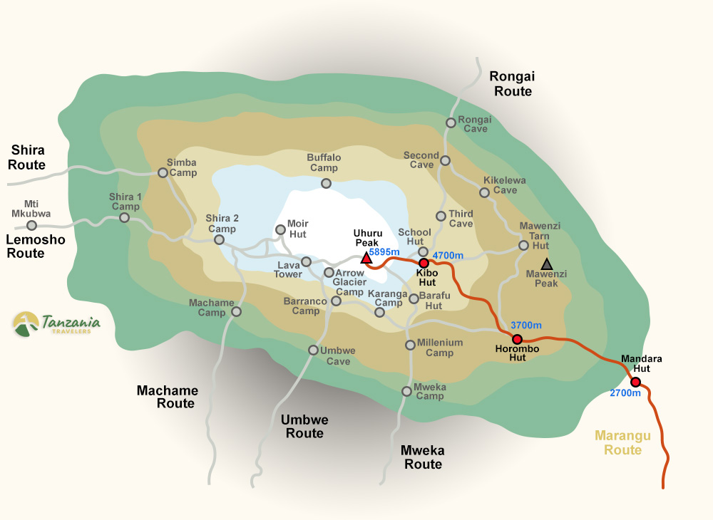
Marangu Route trail map
Duréefrom $1,670

Voie Marangu — 6 jours

Add one more night at Horombo Hut (3,720 m) with an acclimatisation walk to Zebra Rocks (4,000 m), and your chance of reaching Uhuru Peak on Marangu jumps significantly. Same comfortable huts, same route — one extra day for your body to adapt.

Informations clés

Point de départ
Marangu Gate (1,860 m)
Point d'arrivée
Marangu Gate (same route)
Distance
≈ 72 km round trip
Point culminant
Uhuru Peak · 5,895 m
Meilleure saison
Jan–Mar, Jun–Oct
Difficulté
Modéré
Fréquentation
Faible à modérée
Paysages
Exceptionnel
Hébergement
Mountain huts (no tents)

Itinerary at a glance

  1. 1
    Moshi → Marangu Gate → Mandara Hut

    Morning briefing and gear check in Moshi, then a 1-hour drive to Marangu Gate (1,860 m) for park registration.

    Repas : L, D· Mandara Hut · 2,700 m
  2. 2
    Mandara → Horombo Hut

    The forest ends abruptly within an hour and gives way to open heath and moorland studded with giant lobelias and senecios.

    Repas : B, L, D· Horombo Hut · 3,720 m
  3. 3
    Acclimatisation day at Horombo · Zebra Rocks

    The day that makes this itinerary work. 3 hours (acclimatisation).

    Repas : B, L, D· Horombo Hut · 3,720 m
  4. 4
    Horombo → Kibo Hut

    Past the Last Water Point at 4,130 m — from here everything is carried — and out onto 'The Saddle', a stark, wind-scoured alpine desert between Mawenzi and Kibo. 6–7 hours.

    Repas : B, L, D· Kibo Hut · 4,700 m
  5. 5
    Jour du sommet · Kibo → Uhuru Peak → Horombo Hut

    Wake at 23:00 for tea and biscuits and set off by headtorch at midnight. 12–14 hours.

    Repas : B, L, D· Horombo Hut · 3,720 m
  6. 6
    Horombo → Marangu Gate → Moshi

    A long but easy descent retracing the moorland and rainforest path, with a rest stop at Mandara Hut. 5–6 hours.

    Repas : B, L

Pricing comparison

Price per person by group size and trek length.

Taille du groupe6 JOURS5 DAYS
1 personne$2,250$2,100
2 personnes$2,100$1,850
3 personnes$1,900$1,830
4 personnes$1,870$1,800
5 personnes$1,810$1,780
6 personnes$1,800$1,760
7 personnes$1,760$1,740
8 personnes$1,710$1,690
9 personnes$1,670$1,600
10 personnes$1,690$1,580
Prix valables pour les réservations de la saison en cours
The Whiskey Route

Voie Machame

Steeper, wilder, more dramatic — Kilimanjaro's climber's route.

Approaches from the south and crosses to the west before curving back for a southern summit push. Steeper daily gain than Marangu, but excellent scenery and a great built-in acclimatisation profile.

Idéal pour
Fit trekkers with prior multi-day hiking experience.
Difficulté
Difficile
Paysages
Superb — five climate zones, the iconic Barranco Wall
Affluence
Popular — the busiest camping route
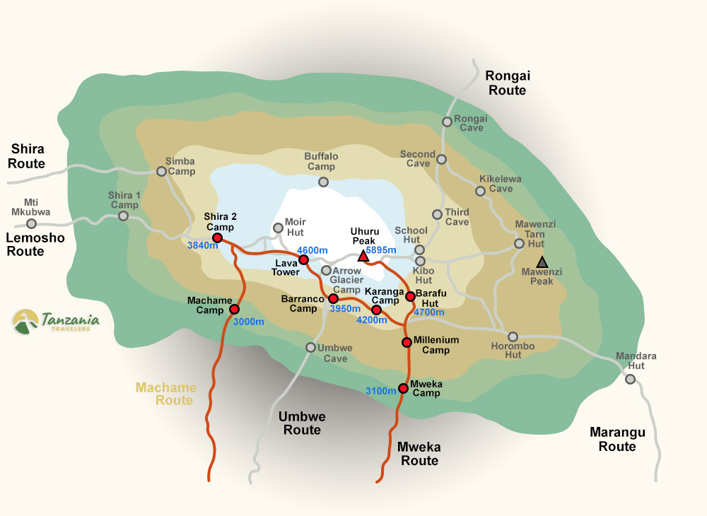
Machame Route trail map
Duréefrom $1,750

Voie Machame — 7 jours

La variante en 7 jours de la très prisée voie Machame ajoute une nuit de repos à Karanga Camp entre Barranco et Barafu. Cette journée supplémentaire en altitude constitue le meilleur atout pour réussir l'ascension du sommet, quel que soit l'itinéraire sur le Kilimanjaro.

Informations clés

Point de départ
Machame Gate (1,640 m)
Point d'arrivée
Mweka Gate (1,640 m)
Distance
≈ 62 km aller-retour
Point culminant
Uhuru Peak · 5,895 m
Taille du groupe
Privé, 1–12 climbers
Meilleure saison
Jan–Mar, Jun–Oct
Difficulté
Modéré
Fréquentation
Faible à modérée
Paysages
Exceptionnel
Hébergement
Tentes de montagne

Itinerary at a glance

  1. 1
    Moshi → Machame Gate → Machame Camp

    Morning briefing and full gear check at your hotel in Moshi. 5–6 hours.

    Repas : L, D· Machame Camp · 3,010 m
  2. 2
    Machame Camp → Shira Camp

    The forest thins within an hour and the trail steepens onto a rocky ridge of the Shira Plateau.

    Repas : B, L, D· Shira Camp · 3,845 m
  3. 3
    Shira → Lava Tower → Barranco Camp

    The classic 'climb high, sleep low' day and the most important for acclimatisation. 6–7 hours.

    Repas : B, L, D· Barranco Camp · 3,960 m
  4. 4
    Barranco → Karanga Camp

    A short, spectacular day. 4–5 hours.

    Repas : B, L, D· Karanga Camp · 3,995 m
  5. 5
    Karanga → Barafu Camp

    A steady climb up the rocky ridge across barren alpine desert to Barafu — Swahili for 'ice' — the summit base camp perched on an exposed shoulder at 4,673 m. 4–5 hours.

    Repas : B, L, D· Barafu Camp · 4,673 m
  6. 6
    Jour du sommet · Barafu → Uhuru Peak → Mweka Camp

    Wake at 23:30 for tea and biscuits and set off by headtorch at midnight, climbing switchbacks of frozen scree at a deliberate pole-pole pace. 12–14 hours.

    Repas : B, L, D· Mweka Camp · 3,068 m
  7. 7
    Mweka Camp → Mweka Gate → Moshi

    A final descent on soft forest trail — muddy after rain, so gaiters are handy — through the rainforest to Mweka Gate. 3–4 hours.

    Repas : B, L

Pricing comparison

Price per person by group size and trek length.

Taille du groupe7 JOURS6 JOURS
1 personne$2,400$2,300
2 personnes$2,200$1,880
3 personnes$2,080$1,840
4 personnes$2,040$1,820
5 personnes$1,900$1,800
6 personnes$1,870$1,780
7 personnes$1,820$1,750
8 personnes$1,800$1,700
9 personnes$1,770$1,680
10 personnes$1,750$1,650
Prix valables pour les réservations de la saison en cours
The Northern Route

Voie Rongai

The quiet northern approach — drier, wilder, less trafficked.

The only route that approaches Kilimanjaro from the north, near the Kenyan border. Drier weather, fewer climbers, and better chances of wildlife sightings in the lower forest zones.

Idéal pour
Climbers who value solitude and want a drier alternative in shoulder seasons.
Difficulté
Modéré
Paysages
Remote — northern wilderness, Mawenzi views, alpine desert
Affluence
Very quiet — the least-trafficked main route
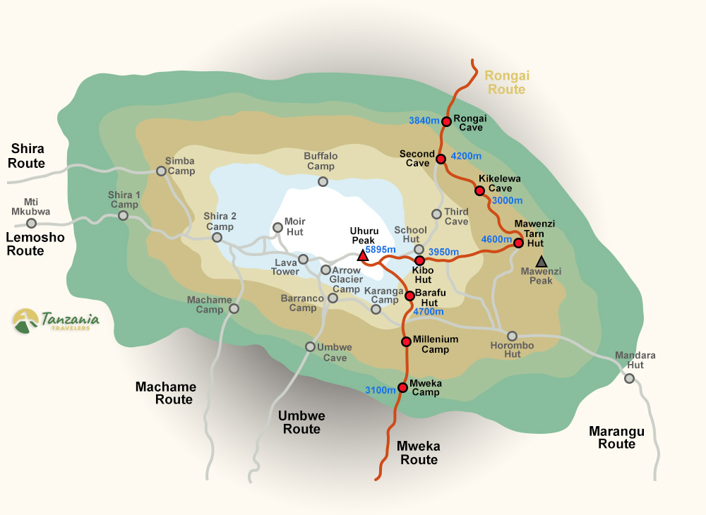
Rongai Route trail map
Duréefrom $1,750

Voie Rongai — 7 jours

Adding a full rest and acclimatisation day at Mawenzi Tarn (4,330 m) makes a huge difference to summit success on Rongai. You still enjoy the quiet northern approach and drier weather, but with your body properly primed for the 5,895 m summit push.

Informations clés

Point de départ
Nalemoru Gate (2,020 m)
Point d'arrivée
Mweka Gate (1,640 m)
Distance
≈ 73 km de point à point
Point culminant
Uhuru Peak · 5,895 m
Taille du groupe
Privé, 1–12 climbers
Meilleure saison
Juin–octobre (versant nord plus sec)
Difficulté
Modéré
Fréquentation
Faible à modérée
Paysages
Exceptionnel
Hébergement
Tentes de montagne

Itinerary at a glance

  1. 1
    Moshi → Nalemoru Gate → Simba Camp

    Morning briefing and gear check in Moshi, then a 3–4 hour drive around the mountain to Nalemoru Gate (2,020 m) near the Kenyan border for park registration.

    Repas : L, D· Simba Camp · 2,625 m
  2. 2
    Simba → Second Cave

    A relaxed moorland climb on a good path as the vegetation thins to heather and everlasting flowers. 3–4 hours.

    Repas : B, L, D· Second Cave · 3,450 m
  3. 3
    Second Cave → Kikelewa Camp

    Leave the main northern trail and traverse east across trackless open moorland beneath the north face of Kibo — a wild, rarely walked section with almost no other climbers. 6–7 hours.

    Repas : B, L, D· Kikelewa Camp · 3,679 m
  4. 4
    Kikelewa → Mawenzi Tarn

    Short but steep, climbing grassy slopes into the alpine zone as the ground turns rocky and bare. 3–4 hours.

    Repas : B, L, D· Mawenzi Tarn · 4,330 m
  5. 5
    Acclimatisation day at Mawenzi Tarn

    The day that transforms Rongai's summit odds. 3–4 hours (acclimatisation).

    Repas : B, L, D· Mawenzi Tarn · 4,330 m
  6. 6
    Summit Day · Mawenzi Tarn → Kibo → Uhuru Peak → Horombo

    Morning trek across 'The Saddle', a stark alpine desert between Mawenzi and Kibo, to summit base camp at Kibo Hut (4,700 m). 15–17 hours.

    Repas : B, L, D· Horombo Hut · 3,720 m
  7. 7
    Horombo → Marangu Gate → Moshi

    A final descent through moorland and rainforest, with a rest stop at Mandara Hut, down to Marangu Gate. 5–6 hours.

    Repas : B, L

Pricing comparison

Price per person by group size and trek length.

Taille du groupe7 JOURS6 JOURS
1 personne$2,500$2,400
2 personnes$2,200$1,890
3 personnes$2,150$1,850
4 personnes$2,100$1,825
5 personnes$1,980$1,800
6 personnes$1,900$1,800
7 personnes$1,840$1,800
8 personnes$1,800$1,750
9 personnes$1,770$1,730
10 personnes$1,750$1,725
Prix valables pour les réservations de la saison en cours
Every Kilimanjaro climb

What's included & route FAQs

These apply to every route above — Lemosho, Machame, Marangu and Rongai. Everything covered on the ground, what's not, and the questions climbers ask most.

Ce qui est inclus

Tout ce qui est inclus sur place, et ce qui ne l'est pas.

Le prix du séjour comprend

  • Tous les transports à destination
  • Hébergement en hôtel, avant et après le trek
  • Toutes les taxes gouvernementales et frais d'entrée aux parcs
  • Tous les repas pendant l'ascension

Le prix du séjour ne comprend pas

  • Location d'équipement personnel
  • Frais de visa pour la Tanzanie
  • Pourboires pour l'équipe de trek
  • Assurance voyage

Route FAQs

The questions climbers ask most.

Not sure which route to pick?

Send us your dates and fitness level — a real guide (not a chatbot) will reply within 24 hours with a personal recommendation.