Machame Route — 6 Days
Overview
Machame is Kilimanjaro's most popular route for good reason, varied scenery, dramatic ridgelines and a sociable trail. It's steeper than Lemosho, so it's best for travellers with prior multi-day trekking experience.
Quick facts
- Start point
- Machame Gate (1,640 m)
- End point
- Mweka Gate (1,640 m)
- Distance
- ≈ 62 km round trip
- Highest point
- Uhuru Peak · 5,895 m
- Group size
- Private, 1–12 climbers
- Best season
- Jan–Mar, Jun–Oct
- Difficulty
- Moderate
- Traffic
- Low to moderate
- Scenery
- Exceptional
- Accommodation
- Mountain tents
Day-by-day itinerary
- ArrArrival Day
Arrival Day
When you arrive at Kilimanjaro International Airport (JRO), a representative from Tanzania Travelers will meet you and transfer you to a hotel in Moshi town. The hotel has everything you need for a comfortable stay: nice rooms, hot water, friendly staff, a pool and Wi-Fi. You’ll spend your first night there. If you arrive at Jomo Kenyatta International Airport (JKIA) in Nairobi, Kenya instead, we’ll pick you up and bring you to Moshi by Shuttle Bus. In the evening, there will be a meeting with the guides to help you get ready for the climb the next day.
Note: Hotel check-in starts at 2:00 PM.
Meals: Breakfast, DinnerShose Farmhouse or Brubru Lodge - 1Day 1
Moshi → Machame Gate → Machame Camp
Today's StatusHiking Time: 5–6 hoursTotal Distance: 11 kmStarting Altitude: 1,800 m (5,905 ft)Final Altitude: 3,010 m (9,875 ft)Elevation Change: +1,210 mHabitat: Montane rainforestMorning briefing and gear check in Moshi, then a 45-minute drive to Machame Gate (1,800 m) for park registration and porter weighing. Picnic lunch, then a steady climb through dense montane rainforest, often muddy underfoot, so gaiters help, with hanging moss, giant ferns and blue monkeys overhead. Camp sits right on the forest edge; hot washing water and dinner are ready on arrival.
Meals: Lunch, DinnerMachame Camp · 3,010 m - 2Day 2
Machame Camp → Shira Camp
Today's StatusHiking Time: 4–6 hoursTotal Distance: 5 kmStarting Altitude: 3,010 m (9,875 ft)Final Altitude: 3,845 m (12,615 ft)Elevation Change: +835 mHabitat: Heather & moorlandA short but demanding day: the trail leaves the forest within the hour and climbs a steep rocky ridge with occasional hands-on steps. As you top out on the Shira Plateau, the caldera of Kilimanjaro's oldest cone, Kibo's glaciers fill the view ahead and Mt. Meru rises above the clouds behind. Afternoon rest, health check and an optional short walk on the plateau.
Meals: Breakfast, Lunch, DinnerShira Camp · 3,845 m - 3Day 3
Shira → Lava Tower → Barranco Camp
Today's StatusHiking Time: 6–7 hoursTotal Distance: 10 kmStarting Altitude: 3,845 m (12,615 ft)Final Altitude: 3,960 m (12,995 ft)Elevation Change: +785 m / −670 m (via Lava Tower)Habitat: Alpine desertThe most important acclimatisation day of the trek. Head east across alpine desert to the 300 m volcanic plug of Lava Tower (4,630 m) for lunch, mild headaches at this height are common and ease as you descend. Drop 670 m into the strange, lush Barranco Valley among forests of giant groundsel and camp beneath the Western Breach and the Heim Glacier.
Meals: Breakfast, Lunch, DinnerBarranco Camp · 3,960 m - 4Day 4
Barranco → Karanga Valley → Barafu Camp
Today's StatusHiking Time: 8–9 hoursTotal Distance: 9 kmStarting Altitude: 3,960 m (12,995 ft)Final Altitude: 4,673 m (15,331 ft)Elevation Change: +713 mHabitat: Alpine desertThe longest approach day. Start early to scramble the Barranco Wall, a hands-on rock scramble past the famous 'Kissing Rock', no technical climbing, then descend and re-ascend into Karanga Valley, the last water source on the route. Continue up the exposed rocky ridge across barren alpine desert to Barafu ('ice'), summit base camp. Early dinner at 17:00, kit prepared, sleeping bag by 19:00.
Meals: Breakfast, Lunch, DinnerBarafu Camp · 4,673 m - 5Day 5
Summit Day · Barafu → Uhuru Peak → Mweka Camp
Today's StatusHiking Time: 12–14 hoursTotal Distance: 17 kmStarting Altitude: 4,673 m (15,331 ft)Final Altitude: 3,068 m (10,065 ft) via Uhuru Peak 5,895 mElevation Change: +1,222 m / −2,827 mHabitat: Arctic → moorlandWake at 23:30 for tea and biscuits and set off by headtorch at midnight, climbing frozen scree switchbacks at a slow pole-pole pace. Sunrise arrives near Stella Point (5,756 m) on the crater rim, Mawenzi glowing below. A further 45–60 minutes along the rim past the Rebmann Glacier brings you to Uhuru Peak (5,895 m). Descend to Barafu for brunch and rest, then down to Mweka Camp in the moorland.
Meals: Breakfast, Lunch, DinnerMweka Camp · 3,068 m - 6Day 6
Mweka Camp → Mweka Gate → Moshi
Today's StatusHiking Time: 3–4 hoursTotal Distance: 10 kmStarting Altitude: 3,068 m (10,065 ft)Final Altitude: 1,640 m (5,380 ft)Elevation Change: −1,428 mHabitat: Montane rainforestA final descent on soft forest trail back into the rainforest and down to Mweka Gate. Sign out of the park and collect your summit certificate, gold for Uhuru Peak, green for Stella Point, followed by the crew's farewell song and tipping ceremony over a celebratory lunch. Transfer to your Moshi hotel by mid-afternoon.
Meals: Breakfast, LunchShose Farmhouse or Brubru Lodge - DepDeparture Day
Departure Day
Spend time at the hotel before being transferred to the airport, based on your flight schedule. The total distance covered on the Machame route is approximately 62 kilometers or 38.5 miles.
Note: Standard hotel check-out time is 11:00 AM. If your flight is later in the day and you require a late check-out, you can extend your stay for an additional cost. This marks the end of your climb!
Meals: Breakfast
Pricing per person
All-inclusive on the ground. Price per person decreases with group size.
| Group size | Price per person |
|---|---|
| 1 person | $2,300 |
| 2 people | $1,880 |
| 3 people | $1,840 |
| 4 people | $1,820 |
| 5 people | $1,800 |
| 6 people | $1,780 |
| 7 people | $1,750 |
| 8 people | $1,700 |
| 9 people | $1,680 |
| 10 people | $1,650 |
| Prices valid for current season bookings | |
What's included
Everything covered on the ground, and what's not.
The Trip Cost Includes
- All transportation in destination location
- Hotel accommodations, before and after the trek
- All government taxes and park entrance fees
- All meals while on the mountain
The Trip Cost Excludes
- Personal gear rentals
- Tanzania visa fee
- Tipping to the trekking crew
- Travel insurance
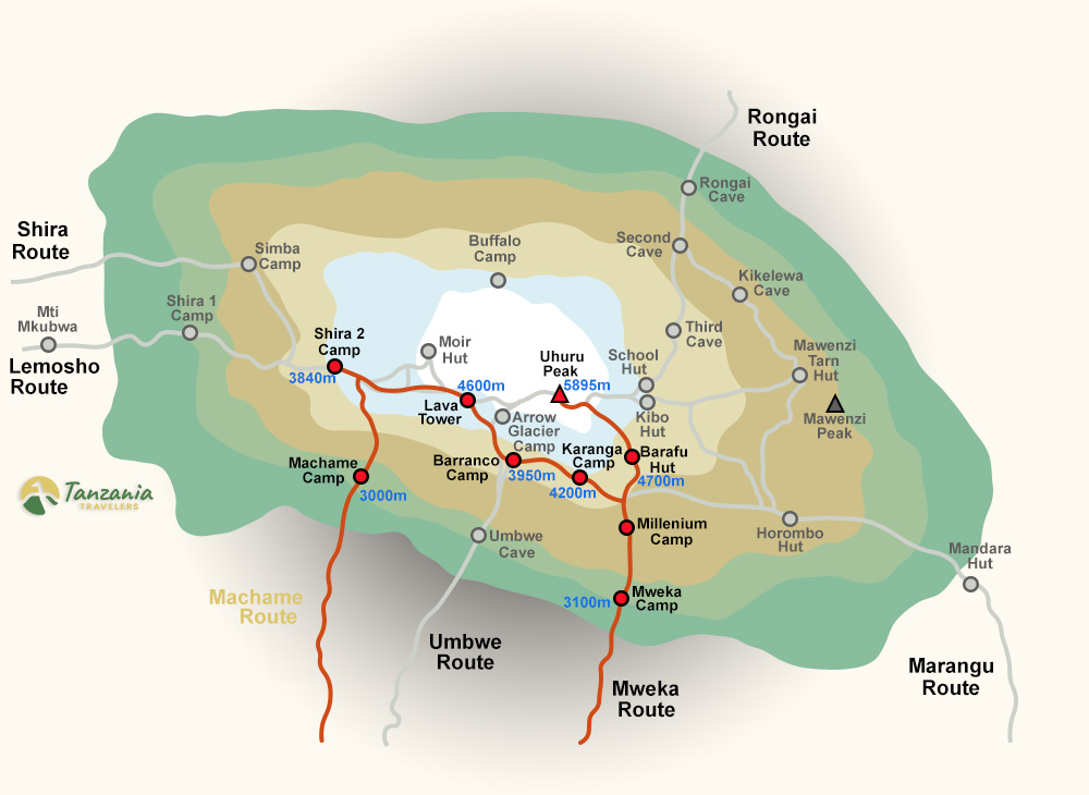
Trail map
A stylised overview of the Machame Route, camps, elevations and summit approach.
Elevation profile
Night-by-night altitude on the Machame Route, the shape of the climb, camp by camp.
Route FAQs
The questions climbers ask most.
Have a question about Machame Route?
Send us your enquiry and a Tanzania-based expert will get back to you within 24 hours with a personalised itinerary, pricing for your group size and answers to any questions you have.
- No deposit required to receive a quote
- Free date & itinerary changes before booking
- Direct reply from a real human, never a chatbot