
Rongai Route — 7 Days
Overview
Adding a full rest and acclimatisation day at Mawenzi Tarn (4,330 m) makes a huge difference to summit success on Rongai. You still enjoy the quiet northern approach and drier weather, but with your body properly primed for the 5,895 m summit push.
Quick facts
- Start point
- Nalemoru Gate (2,020 m)
- End point
- Mweka Gate (1,640 m)
- Distance
- ≈ 73 km point-to-point
- Highest point
- Uhuru Peak · 5,895 m
- Group size
- Private, 1–12 climbers
- Best season
- Jun–Oct (drier northern side)
- Difficulty
- Moderate
- Traffic
- Low to moderate
- Scenery
- Exceptional
- Accommodation
- Mountain tents
Day-by-day itinerary
- ArrArrival Day
Arrival Day
When you arrive at Kilimanjaro International Airport (JRO), a representative from Tanzania Travelers will meet you and transfer you to a hotel in Moshi town. The hotel has everything you need for a comfortable stay: nice rooms, hot water, friendly staff, a pool and Wi-Fi. You’ll spend your first night there. If you arrive at Jomo Kenyatta International Airport (JKIA) in Nairobi, Kenya instead, we’ll pick you up and bring you to Moshi by Shuttle Bus. In the evening, there will be a meeting with the guides to help you get ready for the climb the next day.
Note: Hotel check-in starts at 2:00 PM.
Meals: Breakfast, DinnerShose Farmhouse or Brubru Lodge - 1Day 1
Moshi → Nalemoru Gate → Simba Camp
Today's StatusHiking Time: 3–4 hoursTotal Distance: 8 kmStarting Altitude: 2,020 m (6,627 ft)Final Altitude: 2,625 m (8,612 ft)Elevation Change: +605 mHabitat: Farmland → pine forestMorning briefing and gear check in Moshi, then a 3–4 hour drive around the mountain to Nalemoru Gate (2,020 m) near the Kenyan border for park registration. A gentle start through maize fields and villages, then into pine and juniper forest, the quietest trailhead on Kilimanjaro. Camp at Simba with long views north across the plains.
Meals: Lunch, DinnerSimba Camp · 2,625 m - 2Day 2
Simba → Second Cave
Today's StatusHiking Time: 3–4 hoursTotal Distance: 6 kmStarting Altitude: 2,625 m (8,612 ft)Final Altitude: 3,450 m (11,320 ft)Elevation Change: +825 mHabitat: Heather & moorlandA relaxed moorland climb on a good path as the vegetation thins to heather and everlasting flowers. Expansive views open north toward Kenya and up to the snow dome of Kibo. Short day by design, the afternoon is for rest, hydration and an optional acclimatisation stroll above camp before dinner.
Meals: Breakfast, Lunch, DinnerSecond Cave · 3,450 m - 3Day 3
Second Cave → Kikelewa Camp
Today's StatusHiking Time: 6–7 hoursTotal Distance: 8 kmStarting Altitude: 3,450 m (11,320 ft)Final Altitude: 3,679 m (12,070 ft)Elevation Change: +229 mHabitat: MoorlandLeave the main northern trail and traverse east across trackless open moorland beneath the north face of Kibo, a wild, rarely walked section with almost no other climbers. Kikelewa Camp sits in a sheltered hollow with sunset views over the plains far below.
Meals: Breakfast, Lunch, DinnerKikelewa Camp · 3,679 m - 4Day 4
Kikelewa → Mawenzi Tarn
Today's StatusHiking Time: 3–4 hoursTotal Distance: 6 kmStarting Altitude: 3,679 m (12,070 ft)Final Altitude: 4,330 m (14,206 ft)Elevation Change: +651 mHabitat: Alpine desertShort but steep, climbing grassy slopes into the alpine zone as the ground turns rocky and bare. Camp sits in a dramatic cirque beside a small tarn directly beneath the jagged spires of Mawenzi (5,149 m). Afternoon acclimatisation walk up the moraine, with pulse and oxygen checks before dinner.
Meals: Breakfast, Lunch, DinnerMawenzi Tarn · 4,330 m - 5Day 5
Acclimatisation day at Mawenzi Tarn
Today's StatusHiking Time: 3–4 hours (acclimatisation)Total Distance: 4 km round tripStarting Altitude: 4,330 m (14,206 ft)Final Altitude: 4,330 m (14,206 ft)Elevation Change: +350 m / −350 mHabitat: Alpine desertThe day that transforms Rongai's summit odds. A relaxed morning at camp, then a 'climb high, sleep low' hike onto Mawenzi's lower slopes to around 4,700 m before returning to sleep at 4,330 m. Your guide walks through summit-night pacing, layering and hydration, and the crew re-checks your kit. Rest, eat well and drink 3–4 litres today.
Meals: Breakfast, Lunch, DinnerMawenzi Tarn · 4,330 m - 6Day 6
Summit Day · Mawenzi Tarn → Kibo → Uhuru Peak → Horombo
Today's StatusHiking Time: 15–17 hoursTotal Distance: 27 kmStarting Altitude: 4,330 m (14,206 ft)Final Altitude: 3,720 m (12,205 ft) via Uhuru Peak 5,895 mElevation Change: +1,565 m / −2,175 mHabitat: Arctic → moorlandMorning trek across 'The Saddle', a stark alpine desert between Mawenzi and Kibo, to summit base camp at Kibo Hut (4,700 m). Early dinner and a few hours of sleep, then wake at 23:00 and climb by headtorch from midnight up scree switchbacks past Hans Meyer Cave to Gilman's Point (5,681 m) at sunrise, and on along the crater rim to Uhuru Peak (5,895 m). Descend to Kibo for brunch, then down to Horombo. The longest day of the trek.
Meals: Breakfast, Lunch, DinnerHorombo Hut · 3,720 m - 7Day 7
Horombo → Marangu Gate → Moshi
Today's StatusHiking Time: 5–6 hoursTotal Distance: 20 kmStarting Altitude: 3,720 m (12,205 ft)Final Altitude: 1,860 m (6,100 ft)Elevation Change: −1,860 mHabitat: Moorland → rainforestA final descent through moorland and rainforest, with a rest stop at Mandara Hut, down to Marangu Gate. Sign out of the park and collect your summit certificate, gold for Uhuru Peak, green for Gilman's Point, followed by the crew's farewell song and tipping ceremony over a celebratory lunch. Transfer to your Moshi hotel.
Meals: Breakfast, LunchShose Farmhouse or Brubru Lodge - DepDeparture Day
Departure Day
Spend time at the hotel before being transferred to the airport, based on your flight schedule. The total distance covered on the Rongai route is approximately 73 kilometers or 45.4 miles.
Note: Standard hotel check-out time is 11:00 AM. If your flight is later in the day and you require a late check-out, you can extend your stay for an additional cost. This marks the end of your climb!
Meals: Breakfast
Pricing per person
All-inclusive on the ground. Price per person decreases with group size.
| Group size | Price per person |
|---|---|
| 1 person | $2,500 |
| 2 people | $2,200 |
| 3 people | $2,150 |
| 4 people | $2,100 |
| 5 people | $1,980 |
| 6 people | $1,900 |
| 7 people | $1,840 |
| 8 people | $1,800 |
| 9 people | $1,770 |
| 10 people | $1,750 |
| Prices valid for current season bookings | |
What's included
Everything covered on the ground, and what's not.
The Trip Cost Includes
- All transportation in destination location
- Hotel accommodations, before and after the trek
- All government taxes and park entrance fees
- All meals while on the mountain
The Trip Cost Excludes
- Personal gear rentals
- Tanzania visa fee
- Tipping to the trekking crew
- Travel insurance
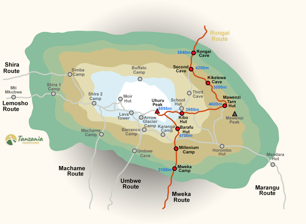
Trail map
A stylised overview of the Rongai Route, camps, elevations and summit approach.
Elevation profile
Night-by-night altitude on the Rongai Route, the shape of the climb, camp by camp.
Route FAQs
The questions climbers ask most.
Have a question about Rongai Route?
Send us your enquiry and a Tanzania-based expert will get back to you within 24 hours with a personalised itinerary, pricing for your group size and answers to any questions you have.
- No deposit required to receive a quote
- Free date & itinerary changes before booking
- Direct reply from a real human, never a chatbot